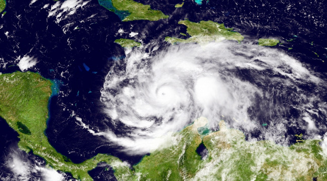
This NOAA photo, which was captured over the Caribbean Sea on Sunday, shows Hurricane Matthew churning away south of Cuba and Jamaica. The storm, which briefly intensified to a Category 5 level on Friday, has since been downgraded to a strong Category 4 hurricane, but its impending strike on Haiti could be catastrophic. Matthew has already left one person dead in Colombia with much havoc forecast for the coming week. Meteorologists have described the storm as one of the most powerful to hit the Atlantic in nearly a decade.
The Weather Channel forecasts a Monday arrival for the “strong and extremely dangerous” Matthew in Haiti, along with hurricane warnings in effect for Cuba and Jamaica, which could see dangerous conditions by nightfall. The storm is expected to travel across the Bahamas throughout the week, and it could reach the United States by next weekend.
For now, all eyes are on Haiti. This morning, meteorologist Mike Thomas evoked Hurricane Katrina as a measure of force for Matthew’s arrival. The storm has since strengthened again with maximum wind speeds of 145 mph.
At 11am winds in #HurricaneMatthew are down to 140mph, still a cat 4. #Matthew could hit #Haiti with same force as #Katrina hit Louisiana. pic.twitter.com/Hx8FRqpuGa
— Mike Thomas (@MikeTFox5) October 2, 2016
The slow moving storm brings potential for isolated rainfall amounts of up to 40 inches in Haiti, which could see “life-threatening flash floods and mud slides.” The storm is expected to also bring potential isolated rainfall amounts of 25 inches elsewhere in the Caribbean, although Matthew could either weaken or strengthen as it moves towards the United States.
Way up in Florida, Governor Rick Scott warned citizens to prepare now for Matthew’s possible future arrival, which he said may be catastrophic. CNN added that it’s still too early to predict the severity of Matthew if and when it strikes the United States.
.@FLSERT & @FLGovScott urge residents along FL Atlantic coast to prepare for Hurricane #Matthew. Impacts will spread far from center. #flwx pic.twitter.com/75JttUmTJn
— Florida Storms (@FloridaStorms) October 2, 2016
(Via The Weather Channel, CBS News & CNN)