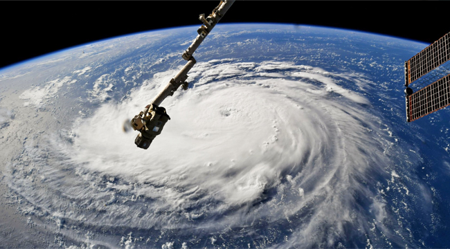
Hurricane Florence, which grew into a massive Category 4 storm on Monday, is dead set on a U.S. East Coast arrival for Thursday. The National Hurricane Service has classified this as an “extremely dangerous” monster, whose path has slightly shifted. This places the projected landfall somewhere along the Virginia and North Carolina coasts — where over 1 million people have been ordered to evacuate. No matter where the storm lands, both states will probably suffer significant damage, as will much of the rest of the East Coast, during what FEMA Director Brock Long predicts will be “a marathon event.”
CNN’s horrifying radar image (below) arrives with word from NOAA Hurricane Hunter Richard Henning. “This is a very large, very powerful hurricane,” he warns. “Everything that you’ve been hearing about this storm in terms of its severity is all true.”
NOAA Hurricane Hunter Richard Henning is currently flying through Hurricane Florence: “This is a very large, very powerful hurricane… Everything that you’ve been hearing about this storm in terms of its severity is all true…" https://t.co/YOoH04RAHW pic.twitter.com/qVUS0N9AY1
— CNN (@CNN) September 11, 2018
ABC News reports that North Carolina is “bracing for a hard hit,” via to Governor Ray Cooper. More than two feet of rain may fall in the Carolinas over days, and Florence is expected to maintain Category 4 status (with sustained winds of at least 140 mph) until landfall. South Carolina Gov. Henry McMaster also warns that Florence is a “bigger” and more “ferocious” storm than 1989’s Hurricane Hugo, qualifying this as the worst hurricane the East Coast has seen in decades. Even more worrisome, Florence is a slow mover, so both Carolinas and Virginia will be hunkering down for a long haul.
Ready for more troubling news? The hurricane weakened slightly overnight, but meteorological scientist Michael Ventrice tweeted this image that indicates how Florence is “undergoing an eyewall replacement cycle.” This process could produce a much larger eye and a stronger storm before landfall.
Major Hurricane #Florence is undergoing an eyewall replacement cycle. Take note of the emergence of a much larger eye at the end of this microwave loop. It is possible that this new, larger eye may support a stronger storm moving forward. pic.twitter.com/gRCIsYJRwl
— Mike Ventrice (@MJVentrice) September 11, 2018
Like the rest of the world, we’ll be following this hurricane for the rest of the week. Until next time, here’s an image from storm chaser Jeff Piotrowski of the ominous clouds approaching Wilmington, North Carolina.
Good morning from Wilmington NC. #HurricaneFlorence #ncwx pic.twitter.com/gY5ZvMVXcS
— Jeff Piotrowski (@Jeff_Piotrowski) September 11, 2018
(Via ABC News, CBS News, CNN & Washington Post)
