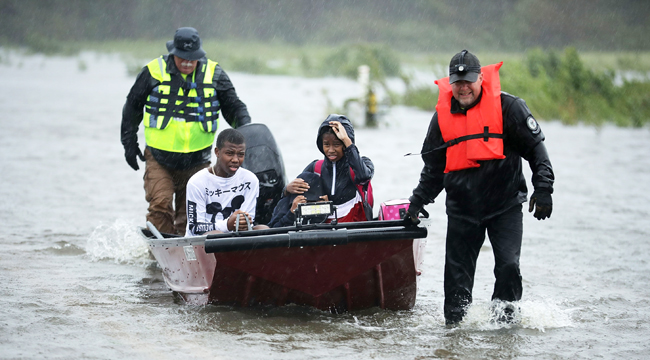
A long weekend stretches ahead for parts of the East Coast after Hurricane Florence made landfall near Wrightsville Beach in North Carolina early Friday morning. The storm arrived in “downgraded” form as a Category 1 with 90 mph winds, but Florence’s mammoth size and accompanying storm surge could cause as much destruction as a Category 3 or 4, and the storm shall linger and dump up to 40 inches in some areas. Currently, at least 500,000 residents are without power, and that number is expected to grow. More urgently, there are ongoing rescues taking place, such as the one shown above by a Civilian Crisis Response Team in James City. Incredible video footage is pouring in as well.
CNN reports that the city of New Bern (located where the Nueces and Trent rivers meet) has already seen a storm surge of 10 feet. There, rescuers have saved over 200 people from their homes, where rising waters have forced people into attics and upon rooftops, and about 150 more people still await rescue. Resident Peggy Perry told CNN that her house flooded “up to the waist” within seconds and continued rising. Meanwhile, Weather Nation has posted footage of waters overtaking New Bern this morning.
Dramatic scenes from #NewBern #NC as water rushes through from #HurricaneFlorence pic.twitter.com/hrW5kVAsSY
— WeatherNation (@WeatherNation) September 14, 2018
Nearby in Belhaven (near the Pugo River), Amy Johnson captured this video, which was Erica Rakow of WPTV.
Flooding from storm surge has gotten really bad in North Carolina. Check out this video from Belhaven, NC. Flooding from the Pungo River is reaching windows of homes. This is just north of New Bern where authorities report at least 350 people needing to be rescued. @WPTV pic.twitter.com/NSpMMkEBgq
— Erica Rakow (@EricaRakow) September 14, 2018
ABC News’ Zoe Daniel also tweeted this early-morning video from Wilmington, where Mayor Bill Saffo told the BBC that power outages could last 10 days.
View from my window 7am #FlorenceHurricane2018 #NorthCarolina power is off pic.twitter.com/BdITqhy2gT
— Zoe Daniel MP (she/her) (@zdaniel) September 14, 2018
The International Space Station posted this footage of Florence’s landfall as seen from above the swirling clouds.
Cameras outside the space station captured views of #HurricaneFlorence on Sept. 14 at 7:41 a.m. EDT, minutes after the storm made landfall near Wrightsville Beach, North Carolina packing winds of 90 miles an hour. pic.twitter.com/aimvyq6OUE
— International Space Station (@Space_Station) September 14, 2018
Going forward, the storm is expected to move further southeast and stretch into South Carolina by Saturday. Florence’s winds currently extend 80 miles beyond the storm’s center, so the rain and storm surge will continue to wreak havoc for days to come.
(Via Weather Channel, BBC & CNN)
