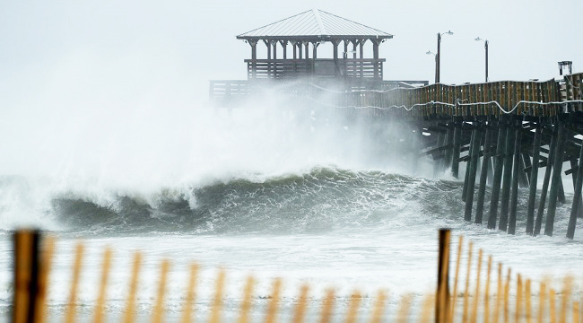
While Hurricane Florence has been poised to become the strongest storm to hit the eastern United States in decades, what was once a Category 4 hurricane has been downgraded to a Category 2. Even so, the “extremely dangerous” storm’s approach has caused local, state and federal officials to announce evacuations along the east coast, especially in North Carolina. As of Thursday afternoon, the storm center is still just over 100 miles from Wilmington, N.C., and the eye is projected to make landfall early Friday.
Those still on the ground in the area are sharing some pretty wild photos and videos on social media, like this drone footage of N.C.’s Topsail Beach:
Drone footage above Topsail Beach, NC approaching high tide ahead of #HurricaneFlorence @breakingweather @accuweather pic.twitter.com/5ZIROSmfk4
— Reed Timmer, PhD (@ReedTimmerUSA) September 13, 2018
Or this shot of an American flag, most likely not long for this world, as it flaps violently in the winds along Cape Fear:
SOUND ON: Tropical storm-force winds lash the North Carolina coast as Hurricane Florence approaches.
For the latest information on Hurricane Florence: https://t.co/ADycvIsbKL pic.twitter.com/ToX7mkTfdK
— ABC News (@ABC) September 13, 2018
One of the more alarming posts, however, includes a new graphic from The Weather Channel that imagines what the storm surge, now projected to reach up to 13 feet in some places, will look like. It’s basically the new CNN hologram, and it’s wild:
This is what 9 feet or more of storm surge from #Hurricane #Florence could look like along the Carolina coast. Know what to expect where you live as our 24/7 coverage continues. #ImmersiveMixedReality #IMR pic.twitter.com/KN4G0XxXNc
— The Weather Channel (@weatherchannel) September 13, 2018
Others, like reporters and residents who are situated along the east coast to either cover or ride out the storm, are now posting the beginnings of these very storm surges:
#HurricaneFlorence still continues to barrel toward the coast of the Carolinas and is already causing storm surges on the Outer Banks. Here's video from Avon, N.C. as water breaches the dunes! (Video credit: Jason Cole Photography) https://t.co/xGpaSmoiBv pic.twitter.com/NUFsMCfv6f
— 13News Now (@13NewsNow) September 13, 2018
#13stormmode High tide at Chic’s Beach eroding the sand. pic.twitter.com/6V47byDeQT
— Ben Read (@benphoto716) September 13, 2018
Photo taken from Topsail Beach, NC. The center of Hurricane Florence is still 115 miles ESE of Wilmington, NC. pic.twitter.com/J9TcXBpFXH
— Rachel Piscitelli (@RachPiscitelli) September 13, 2018
Storm surge already over taking the homes here on the barrier island. #hurricaneflorence #ncwx pic.twitter.com/XWlFmopp8W
— Jeff Gammons (@StormVisuals) September 13, 2018
#HurricaneFlorence right now… Tonight, these docks will likely be underwater as 7+ storm surge… plus high tide flood this whole area. pic.twitter.com/SZXzspOeoR
— Gadi Schwartz (@GadiNBC) September 13, 2018
Water surges over dunes and past homes on Hatteras Island #HurricaneFlorence
Hatteras cut off from mainland after N.C. 12 closure https://t.co/yhuTw4CNRN pic.twitter.com/96ZpjaTAwZ
— The Virginian-Pilot (@virginianpilot) September 13, 2018
https://twitter.com/Jeff_Piotrowski/status/1040269367160782849
Be safe out there!
